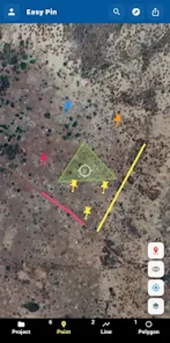
Field Pin: Android field GIS for mapping, measurement, and photo records
Field Pin, developed by Aero Solution, is a mobile GIS app for field surveying and site documentation. It records device GPS coordinates and lets users create points, polylines, and polygons to capture locations, routes, and areas. The app includes photo attachments, interactive map layers, and project-based organization for managing separate surveys. Field Pin targets surveyors, inspectors, and GIS professionals who need a portable tool for on-site data collection and later export to desktop GIS environments.
What the app does for on-site geographic data collection
Field Pin turns an Android device into a field data recorder by using the device's built-in GPS to capture coordinates and by letting users add mapped features as points, polylines, and polygons. It supports area and distance measurement along drawn features and links photos to individual pins for visual documentation. Project folders keep separate surveys distinct so field teams can manage multiple sites without mixing datasets.
How it handles location accuracy and measurement tasks
The app relies on the device GPS for position capture, which means recorded precision depends on the mobile receiver and satellite conditions; distance and area calculations derive directly from those captured coordinates. Field Pin presents measurement results in the mapping view so users can verify geometry immediately. Export options are intended for later office verification and more rigorous spatial analysis in desktop GIS.
Device access, authentication, and required permissions
Field Pin runs on Android and requires access to device location services to collect GPS data, and it uses Google Sign-In for account authentication. The connection model is mobile-first, operating locally on the device for data capture; export capabilities move collected geometry to external GIS tools for post‑processing. No device modification is necessary to use the app's core mapping functions.
Appropriate use cases and limits around platform policy
The app is aimed at field surveyors, infrastructure inspectors, and environmental researchers who need on-site mapping and photo-backed records for later analysis. It supports professional workflows by organizing projects and enabling exports for desktop GIS. Users are responsible for ensuring their use complies with applicable platform terms and local regulations, particularly when survey data intersects with regulated work or restricted areas.
Field Pin is a practical choice for field teams requiring mobile GIS capture
Field Pin is a practical option for professionals who need to capture mapped points, routes, and areas with photo-backed records on Android devices; its project organization supports multi-site work and export for office analysis. Expect data quality to match the device GPS and confirm that Google Sign-In fits your authentication needs before deploying it across a team.